|
San Gabriel Mountains
The following description is excerpted from the Los Angeles Times Hiking Guide by Jerry Schad.
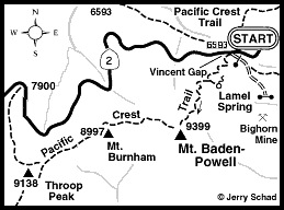
Massive Mt. Baden-Powell stands head and shoulders above the smoggy haze that often enshrouds the lowlands of the Los Angeles Basin and Inland Empire. From Baden Powell's flattish top, the brown Mojave Desert floor stretches interminably inland towards some hazy vanishing point, and the disembodied summit ridges of mountain ranges as far west as Ventura County and as far south as San Diego seem to float over opaque blankets of haze. Santa Catalina Island, and sometimes other islands, are visible on an average early-summer morning. Named in honor of Lord Baden-Powell, the British Army officer who started the Boy Scout movement in 1907, Mt. Baden-Powell soars higher (9399 ft) than any other peak in the San Gabriel Mountains--except for Mt. San Antonio (Old Baldy) to the east. Thousands of hikers troop to Baden-Powell's summit yearly, most of them by way of the trail from Vincent Gulch on the Angeles Crest Highway. To climb Baden-Powell, start at the large Vincent Gulch parking area at mile marker 74.8 on Angeles Crest Highway (Highway 2). Beginning from an elevation of 6,765 ft at the parking lot, some 40 switchbacks and 3.8 miles of steady ascent are required to reach the summit at 9,399 ft. A little over a mile up this trail, at the 15th switchback, a side trail leads about 200 yards east to a dribbling pipe at Lamel Spring. This is the only normally dependable source of water along the route. Over 3540 hours of volunteer labor by Boy Scouts were required to build this trail, which was completed in 1982. About halfway up the trail, Ponderosa pines dominate the forest, but keen eyes will spot a few limber pines, which are relatively rare in Southern California. Look closely at the needles--Ponderosa pines have needles in bundles of two, whereas limber pines have bundles of five. Baden-Powell's summit is marked by an impressive monument constructed in 1957 by the Boy Scouts. Weather-beaten Ponderosa and Limber pines dot the summit area, which also offers a panoramic perspective of rugged Sheep Mountain Wilderness to the south. As the name suggests, this wilderness protects the habitat of the Nelson bighorn sheep, which number about 700 in the San Gabriel Mountains. Early-morning sightings of bighorns are not unusual on and near Mt. Baden-Powell. At a moderate pace, including a few short breaks, this 7.6-mile hike should take about 3 hours to reach the summit, and another couple of hours to return. Snow accumulations can blanket the area until June, and sometimes later. During the summer of 1998, snow kept the road to the Vincent Gulch parking lot closed until mid-summer. So call ahead for road conditions before venturing out. After the snow melts, there is little or no water to be found on the route, so fill your canteens at home and bring them! An alternate route that traverses the ridgeline from Throop Peak to Mt. Burnham to Baden-Powell, and requires a car shuttle, is described by Jerry Schad in the Los Angeles Times Hiking Guide. The Throop Peak to Baden-Powell traverse adds another mile and a half, with another thousand feet of total elevation gain. The quickest route from Bakersfield is to take Highway 58 to Mojave, then Highway 14 to Lancaster. Exit at Palmdale and follow Route 138 east past Pearblossum. Exit southwest onto the Angeles Crest Highway (Highway 2) and continue another 10 miles to the Vincent Gulch Parking lot. |