Dinkey Lakes Loop
Dinkey Lakes Wilderness in the Southern Sierra
Highlights: Dinkey Lakes Loop is an easy backpack of 7 to 9 miles (round trip) with walls of glaciated granite, and mountain lakes stocked with trout in a High Sierra setting.
Directions: The drive takes 3-4 hours from Bakersfield.
- From Fresno and Tulare, take Highway 168 towards Huntington and Shaver Lakes (i.e., towards Camps Kern and Chawanakee). As you enter the town of Shaver Lake, turn right (east) on Dinkey Creek Road.
- After 9.1 miles, passing Camp Chawanakee on the way, turn left (north) on semi-paved Rock Creek Road and follow it for 6 miles.
- At a T intersection with a sign, turn right and drive 4.7 miles on rough road to the crest of a wooded ridge.
- Turn right onto a narrow dirt track on the right side of a wooded ridge. When the steadily worsening road divides after 2 miles, stay left. A parking lot at the Limestone Campsite is reached when the road ends a short distance ahead.
Trailhead: (click here for a map)
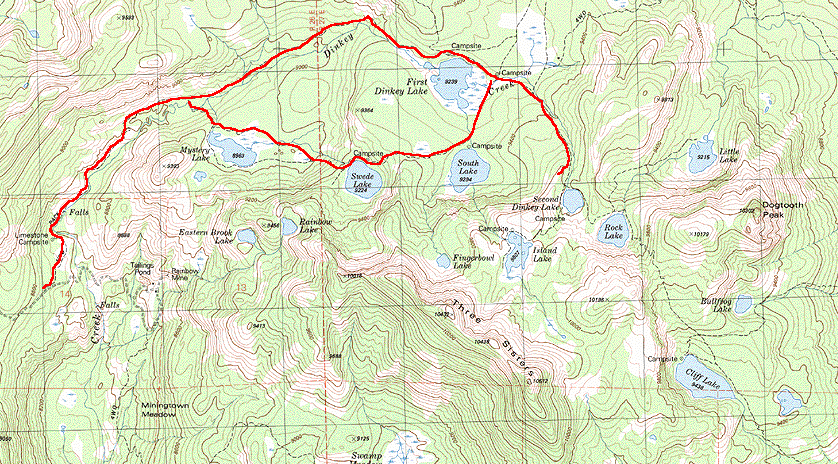
From the parking lot, the trail for about ˝ mile follows an old 4-wheel drive road on the NW side of Dinkey Creek that degenerates into a trail, then climbs another mile to a trail junction. This is the loop intersection for this hike. For the next 4 miles, the south branch of the trail climbs to Mystery Lake, passes Swede and South Dinkey lakes, then drops to First Dinkey Lake, and follows Dinkey Creek downstream back to the trail junction and ultimately to the parking lot at trailhead. Because there are many trail intersections, be sure to bring a map. Hiking distance for this loop is about 7 miles total. A short side trail on the east side of First Dinkey Lake, at the top of the loop, climbs steeply ˝ mile to Second Dinkey Lake, then another ˝ mile to Rock Lake. If this side trip is added to the lower loop, it makes a total roundtrip distance of 9 miles.
Maps: Dogtooth Peak 7˝ minute topographic quadrangle
Cautions:
- Becuase elevations range from 8560 ft at the trailhead to 9800 ft at Rock Lake, be wary of altitude sickness.
- A Wilderness Permit is needed and can be obtained from the Pineridge Ranger District office in Prather (near Shaver Lake). Permit requests can be addressed to P.O. Box 559, Prather, CA, 93651.(559-841-3311).
- Because of heavy use, giardia is a risk. Be sure to purify your water.
- Mosquitos can be ferocious in late June and early July. Be sure to take plenty of insect repellent!
- Bears can be a problem, so take the appropriate precautions and hang our food properly.
Attractions:
- There is a collapsed cave in the limestone outcrop at the trailhead.
- A short distance from the Limestone Campground at the trailhead, there is a nice waterfall on Dinkey Creek.
- These lakes are well stocked with fish. Don't forget the fishing poles.
|